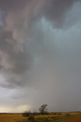
I started the day off near Ralls, TX (just east of Lubbock) watching early convection fire along an old outflow boundary to the south of there. A couple of severe warned storms were ongoing early but I had my main focus on more leftover outflow boundaries in the Plainview to Childress area. Before long, a few towers started to erupt on another boundary in my target area and I intercepted a few of them in the Floydada area. We were in between two nice rotating supercells near Whiteflat, TX when I noticed the one to my west about 10-15 miles quickly producing a large barrel tornado.
It slowly transitioned into a tall, dusty looking stovepipe with more intense circulation just near the ground.
Quickly changing over to a stovepipe cruising through the windfarm before it got wrapped in rain and roped out.
The crazy late April week of chasing may continue today with a marginal setup in the southern plains. I'll be looking for and outflow boundary or just playing the slow moving cold front in central Oklahoma somewhere. Things may once again fire off a front tomorrow in Oklahoma before it crashes south for the weekend.
Thursday, April 30, 2009
Tuesday, April 28, 2009
Storm Chances this Week, Website Stuff
We went ahead and called off today's chase in southwest TX / eastern NM. Hopefully it was the right decision and plus I have a lot of stuff back here in Norman I need to take care of. That said, there are multiple chase opportunities coming up this week. Wednesday presents a nice dryline stretching from western KS back south into the TX panhandle. Morning cloud cover/precip may make this a difficult forecast though. Thursday and Friday will be centered around a slow moving cold front in the southern plains.
Sunday's chase in western Oklahoma was a great success for us and other chasers who were on that particular storm. Other than that the high risk for tornadoes across much of Oklahoma was a bust. I'll have video up hopefully within the next week or so of that event.
Went ahead and said goodbye to capturethestorm.com. I'll be instead sticking with the blog and posting videos to youtube (both are free). Visit both sites frequently as I'll update here very frequently since my original site is no longer around.
http://www.youtube.com/user/capturethestorm
Monday, April 27, 2009
Western Oklahoma Tornadoes April 26, 2009
Just a few quick video grabs of the nice tornadoes Cassie, Brandon McClung, and I intercepted yesterday.
A small rope tornado touches down north of Roll, OK.
Rope tornado rotates around new tornadic circulation.
Beginning of next larger tornado.
It grows as we race towards it.
More shots of nice tornado ripping across the countryside.
A small rope tornado touches down north of Roll, OK.
Rope tornado rotates around new tornadic circulation.
Beginning of next larger tornado.
It grows as we race towards it.
More shots of nice tornado ripping across the countryside.
Monday, April 13, 2009
Sunday, April 12, 2009
Lightning, Upcoming Events
We ventured out just west of Norman last night to try and shoot some lightning out of a round of thunderstorms. A few pics here...
Not sure what is going on here?
Out of focus but you get the idea.
A chance at some hail under the upper low exists today in southwest OK and northwest TX. May wonder out that way if low clouds clear out soon.
Next week has some interesting looks to it still and Thursday through Saturday all have potential.
Saturday, April 11, 2009
More Updates
Our chase on Thursday was pretty much a bust. Not much to show for except maybe some pea sized hail. Our group was going to head toward west TX today but bailed out on that plan as well. Probably should have as I am watching some nice storms near my favorite place in the plains to chase (Andrews-Gaines-Dawson Counties). Tomorrow holds at least some promise for some hail and possibly structure near the Red River and parts of western north TX and southern OK. I'm also watching our next possible system that will effect much of the plains next Wed-Fri (15-17) and possibly beyond. That's about it for now, I'll post again tomorrow if there are plans to chase anything.
Thursday, April 9, 2009
Thursday's Chase
Today we'll be heading towards the OK/KS border to start things off. A small threat of tornadoes may develop in vicinity of the sfc low early in the day and I'd like to be in position early if that materializes. Other than that, the main show will come a bit later in parts of southeastern Kansas and northeast Oklahoma where storms are forecast to fire near the retreating warm front and dryline. Here, a more classic setup may unfold with the possibility of some long lived supercells with giant hail and a few tornadoes. More later....
Monday, April 6, 2009
Upcoming Storm Chances
A couple of chase opportunities are on the horizon. First would be Thursday 9th somewhere in KS/OK with a fast moving system that may or may not have enough moisture to work with. Another chance would be Saturday 11th somewhere in west or southwest TX assuming moisture return can make it there in time. I'll be watching both of these days very closely!
Also, I'll try to post more often with forecasts, in the field updates, and reports once the brunt of the season gets here.
Subscribe to:
Posts (Atom)