Sunday, December 30, 2007
Saturday, December 29, 2007
Saturday, December 22, 2007


Friday, December 21, 2007
Updates & Winter this Week
Also, the next 7 days will present quite a few oppurtunities for light snow here in central Oklahoma. Check out Norman's WFO for more info.
Sunday, December 9, 2007
Round one of ice, Another to follow


The freezing line moved south overnight and a band of heavy freezing rain developed. Here a radar pic showing the convective banding feature this morning.

More to come later with possibly a heavier event going into tomorrow.
Saturday, December 8, 2007
Winter Storm to affect the Southern Plains

There will likely be a break in the activity on Sunday during the the day and into the evening but another round of possibly heavier precip is expected on Monday. Here is a graphic from NWS Lubbock depicting the situation.

The Hydrometeorological Prediction Center paints a picture with high QPF amounts and a good chance of accumulating ice for Monday.

The reason for ice rather than snow for much of the region is the depth of the shallow air. A warm layer above the surface (~850mb) will persist as the shallow subfreezing artic air works its way in underneath this warm layer. Here's the sounding from Norman, OK this morning showing the large temperature inversion and the cold layer just near the surface.

Monday, November 19, 2007
Cold for Thanksgiving

The cold air will stay in place through the weekend while another storm may take shape in the southwest US. Depending on how this storm ejects to the east, there will be a chance for a round of wintry precip on the southern plains in the Fri/Sat/Sun (23-25) timeframe. Here's a graphic from Lubbock NWS.

ECMWF for Sat. morning shows the 500 hPa vort max situated over Arizona, a much slower solution than the GFS. Track of this low will be important for any snowfall throughout the region.
ECMWF:

GFS:

Locations in the eastern OK panhandle will likely see cold temps throughout the week with highs struggling to hit 40F. The coldest mornings seem to be Thursday and Friday mornings as widespread upper teens could be a reality. Very slight chance of a snow flurry or two Wednesday morning but a higher chance of some wintry precip may come later in the week (23-25) with the associated storm system mentioned above. Still a lot of details to pinpoint before a quality forecast could be made though.
Thursday, November 15, 2007
Cold on the Way
WEST TO NORTHWESTERLY FLOW ALOFT WILL BE SITUATED OVER THE
CENTRAL PLAINS AGAIN TO BEGIN THE PERIOD. NUMERICAL MODELS ARE IN
SOME AGREEMENT INDICATING THIS PATTERN CONTINUING THROUGH MONDAY
UNTIL AN UPPER LEVEL TROUGH OF LOW PRESSURE BEGINS TO COME ASHORE IN
THE PACIFIC NORTHWEST. HOWEVER, THE GFS AND CANADIAN ARE A JUST A
BIT MORE AMPLIFIED WITH THE TROUGH THAN THE ECMWF DIGGING SOUTHWARD
AS IT MOVES INTO THE ROCKY MOUNTAIN REGION BY EARLY TUESDAY. THE
MODELS REALLY BEGIN TO DIVERGE BY WEDNESDAY. THE ECMWF BEGINS TO
SHOW THE UPPER LEVEL TROUGH DIGGING DEEP OVER THE DESERT SOUTHWEST
WITH A MORE POSITIVE TILT AND CLOSING OFF OF THE LOW. THE GFS CLOSES
OFF THE LOW AS WELL BUT INDICATES THE UPPER LEVEL TROUGH BECOMING
LESS AMPLIFIED THAN THE ECMWF AND LESS POSITIVELY TILTED. THE MODELS
REALLY BEGIN TO SPLIT APART BY DAY SEVEN WITH THE GFS SHOWING THE
UPPER LEVEL LOW EJECTING NORTHEAST INTO THE GREAT LAKES REGION WHILE
THE ECMWF KEEPS THE UPPER LOW CLOSED OFF AND OVER THE DESERT
SOUTHWEST. THE 12Z GFS ENSEMBLE MEMBERS LEANED MORE TOWARDS THE
OPERATIONAL GFS BUT A LITTLE SLOWER. REGARDLESS, EXPECT MUCH COLDER
AIR TO BEGIN ADVECTING INTO WESTERN KANSAS BY TUESDAY IN WAKE OF A
PASSING COLD FRONT. ALSO EXPECT THE POSSIBILITY OF PRECIPITATION TO
PICK UP IN THE TUESDAY/WEDNESDAY TIME FRAME IN ASSOCIATION WITH THIS
UPPER LEVEL SYSTEM. HOWEVER, UNCERTAINTY PREVAILS THIS FAR OUT WITH
TIMING BEING AN ISSUE ALONG WITH PRECIPITATION TYPE. THE LATEST 12Z
GFS RUN AND 12Z GFS MODEL SOUNDING INDICATES COLDER LOW AND MID
LEVELS WITH TEMPERATURES WELL BELOW 0(C) BY 00Z THURSDAY. THE 12Z
ECMWF IS SOMEWHAT WARMER THAN THE GFS. THE GFS TRACKS THE LOW OVER
THE CWA WHILE THE ECMWF LAGS 24-48 HOURS BEHIND AND TRACKS THE LOW A
LITTLE FURTHER NORTH. WILL KEEP GOING POPS AND WEATHER TYPE DUE TO
THIS MUCH UNCERTAINTY THIS FAR OUT.
http://www.crh.noaa.gov/product.php?site=NWS&issuedby=DDC&product=AFD&format=CI&version=1&glossary=1
Monday, November 12, 2007
Boring Warm November so far
Sam
Tuesday, October 16, 2007
Severe Outbreak Wednesday


...THE ENVIRONMENT WILL BE
FAVORABLE FOR SUPERCELLS WITH VERY LARGE HAIL/ LOCALIZED DAMAGING
WINDS. AND...LARGE LOW-LEVEL HODOGRAPHS BENEATH A 40-50+ KT
SOUTHERLY 850 MB JET WILL SUPPORT THE RISK FOR A FEW
TORNADOES...SOME OF WHICH COULD BECOME STRONG ACROSS PARTS OF
CENTRAL/EASTERN KANSAS AND OKLAHOMA.
Monday, October 15, 2007
Large Gustnado captured in W. Oklahoma
Friday, October 12, 2007
Plains Storm Chase this Weekend
Wednesday, October 3, 2007
Severe Episode Possible this Weekend
Saturday, looks to be potentially a big day depending on timing of the associated lift in the mid levels as well as any jet streaks rounding the base of the trough. Again, the cap will be strong but it appears there will be enough forcing to overcome it. Below is the NAM/WRF 12z run from today at 500mb and 850mb:


Still pretty far out but Saturday sure holds potential in central Nebraska.
On Sunday, the picture is a bit less clear due to differences in the medium range models. Most WFO's around the plains seem to favor the faster ejection of the trough to the northeast, much like the latest ECMWF runs. The GFS on the other hand shows a slower solution that cuts the low off further from the northern branch of the jet and slowly drifts it towards the southern plains. Here is the GFS 12z from today for 500mb:

I will post details hopefully Thursday night or Friday as to what days I'll be chasing and where.
Tuesday, September 18, 2007
Friday, September 14, 2007
Severe Chances Next Week?
Wednesday, September 12, 2007
T.S. Humberto to make landfall between Galveston and High Island, TX
Here's a link to Galveston NWS update page.
http://www.srh.noaa.gov/hgx/graph_haz/graphicastHGX1.php
Here's a view of Humberto on radar (5:34pm).

Tuesday, September 11, 2007
Cool Night Ahead

Thursday, September 6, 2007
Old Lightning Pics


I am still hopeful that the fall season will present one or two more storm chases before 07' is over. After that, I'm ready for winter and all it has to offer. I still plan to chase a blizzard if the opportunity presents itself while I'm out of school. Here are some winter storms I've experienced.
Sunday, September 2, 2007
Hurricane Felix now a Category 4
As of the latest update from the National Hurricane Center, Hurricane Felix is now a Cat. 4 storm with sustained winds of 140 mph. Hurricane hunters found the lowest pressure to be 956mb. The storm should continue its westward track with slight wobbles to the north and eventually effect Honduras and Belize as a major hurricane.

Monday, August 27, 2007
Cap is dominating, SFC based storms unlikely before dark

The latest MD issued by the SPC states the same thing: ....POTENTIAL FOR SURFACE BASED STORMS FARTHER SOUTH APPEARS LIMITED...BUT THESE AREAS WILL CONTINUE TO BE MONITORED.

Sunday, August 26, 2007
Tornadoes in ND, Severe Weather likely again Tomorrow

Wednesday, August 22, 2007
Gorilla Hail in South Dakota

Tuesday, August 21, 2007
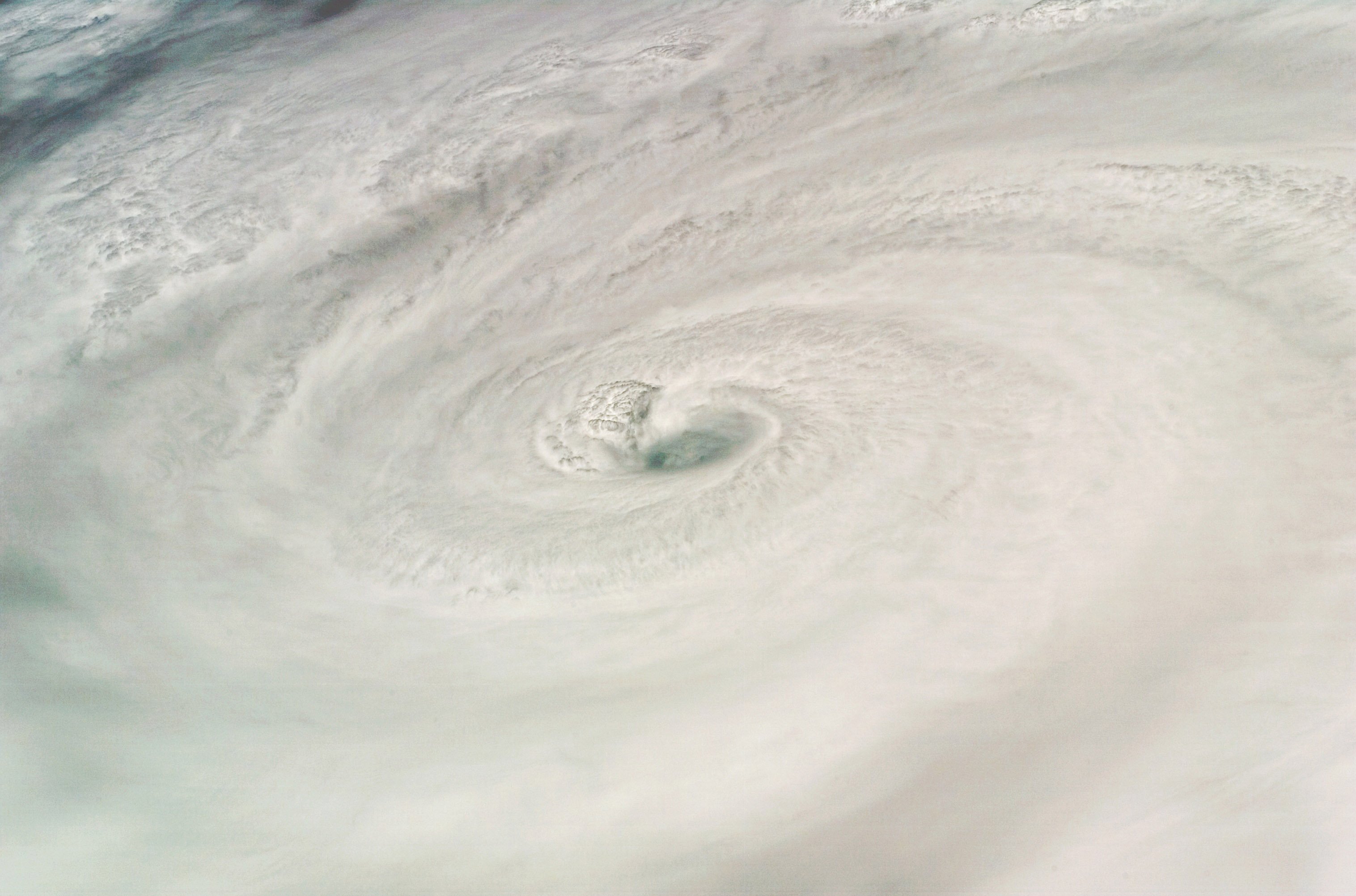
New pic from Hurricane Dean
 Picture of Hurricane Dean taken by shuttle Endeavor near peak intensity in the Caribbean Sea.
http://upload.wikimedia.org/wikipedia/commons/9/90/HurricaneDean.jpg
Severe storms along cold front rest of this week.
A cold front dragging through the central US will present a focus for severe weather opportunities the rest of this week as it drags slowly south. Fairly zonal, mid level flow of 30 - 50 kts atop the frontal location coupled a decent LLJ the next couple of days could set the stage for numerous hail and wind report along with some isolated tornadoes wherever storms can stay discrete and not get undercut by the front.
Threat locations:
Tuesday 21st - Nebraska, southeast South Dakota, northern Kansas, Iowa
Wednesday 22nd - much of Iowa and Nebraska, eastern Colorado, northern Kansas
Thursday 23rd - Mainly Kansas and eastern Colorado
Monday, August 20, 2007
Severe Weather Possible this Afternoon
 EHI values, which is measured by the amount of CAPE and storm relative helicity (in this case the lowest 1km), are above 5 for eastern Nebraska. In general, 0-1km EHI's above 2 can support a decent tornado threat.
 A weather watch, possibly a tornado watch, may be needed later this afternoon for the affected areas.
Sunday, August 19, 2007
Tropical Depression Erin restrengthens over Oklahoma


Over 9" in 24 hrs at Fort Cobb, over 5" at Norman. Like I said, there is widespread flooding and river are beginning to overflow their banks.
Saturday, August 18, 2007
A Break from the Heat


Friday, August 17, 2007
DEAN's forecast track shifted slightly north; may effect Texas


Wednesday, August 15, 2007
TS Erin: Heavy Rain and possible Tornadoes for the Texas Coast

Brief, weak tornadoes are possible beginning tonight and going into the day on Thursday from and area near Galveston south along the coast to about Corpus Christi. The moist, unstable tropical air mass will be in place along with favorable wind profiles in this region to support isolated tropical type funnels, waterspouts, and weak tornadoes. SPC has just raised their tornado probabilities in the latest outlook.

Tuesday, August 14, 2007
Soon to Be TS Dean, Trouble in Gulf as well
Of more importance now is the possible development of Tropical Depression in the Gulf. Invest 91L is just north of the Yucatan and some models forecast it to hit the Texas coast as a TS or a weak hurricane.
More in depth updates tonight....
Sunday, August 12, 2007
Invest 90L


Another area to monitor is the Caribbean where widespread convection is found this morning. Shear over the area isn't the most favorable but if there is enough low level convergence, a low level circulation could form.

Friday, August 10, 2007
Hurricane Season is here
 Models are beginning to show increased tropical cyclone activity in the Atlantic Basin over the next few weeks. Not to say one model will verify over another, but the consensus of the upcoming pattern is quite similar. Above, NAM shows a system located near the Yucitan peninsula. Below, the CMC has had a similar feature for a couple of runs now.
The GFS on the other hand, does not pick up on this potential system but has been consistent with something developing off the African coast sometime next week.

A look at the Atlantic Basin now shows some convection in the Carribean and some convergence along about 10N.

I wouldn't give up on this season at all. Things may just be getting started and I would almost bet on seeing another named system within the next two weeks.
Thursday, August 9, 2007
Possible Chase Friday 10th

